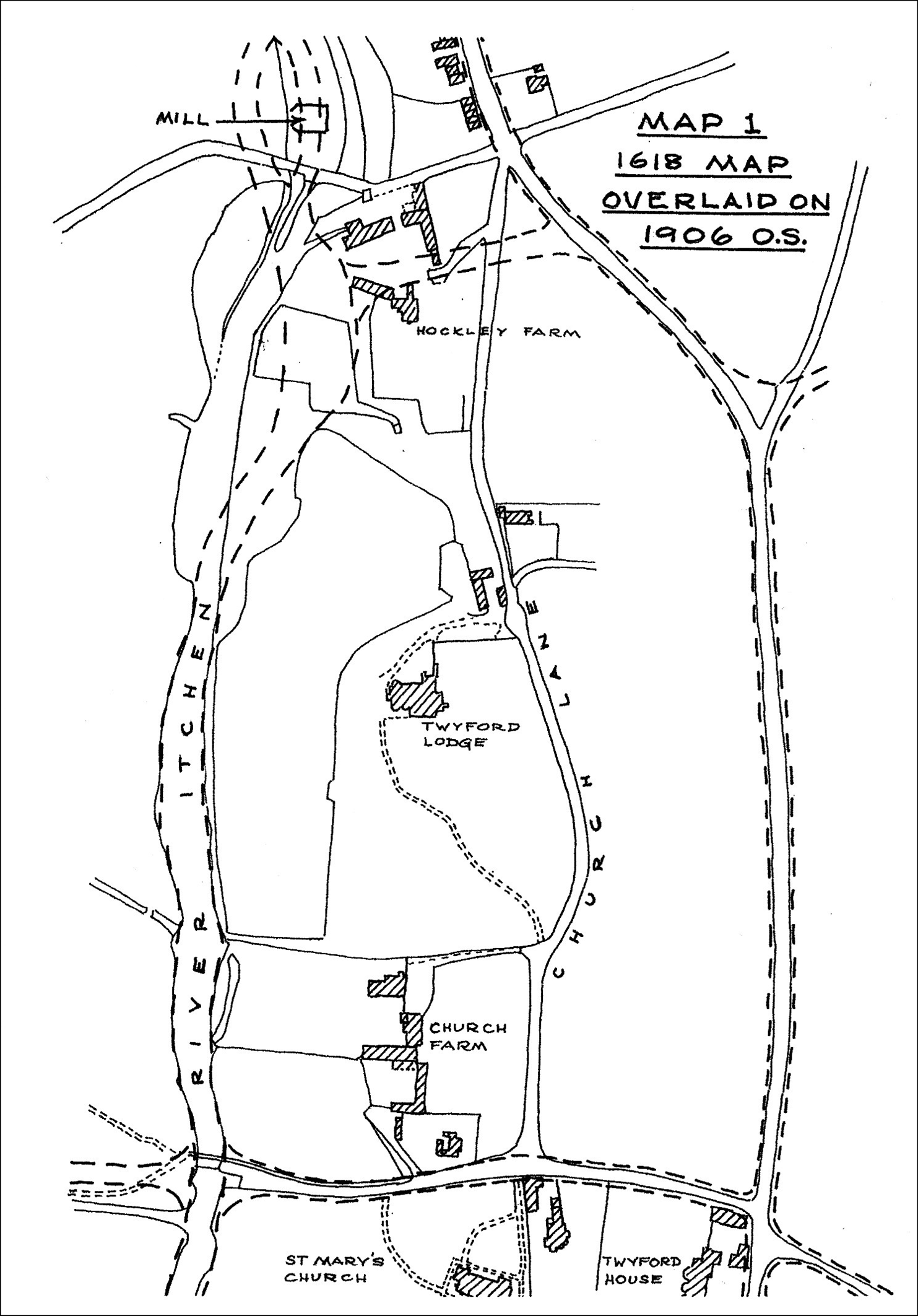
In addition to all this but rather earlier, was the
building of the Itchen Navigation in1710 and Lady
Mildmay’s new water meadows constructed to the east
of the river, with the leat you can cross Nethen
Lane today.
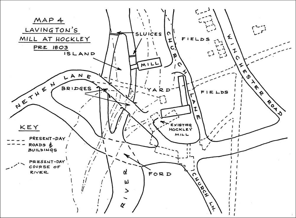
Map 4 shows this area before all these changes in
more detail than Map 2. The modern layout is shown
dotted.
George Hoar of Twyford Lodge and the Mill
My guess is that the story runs thus:
In the
1790’s, the new owner of Twyford Lodge, Mr George
Hoar, a senior employee of the East India Company
recently returned from India (where he had been
paymaster of the British Army) saw the potential for
creating a small landscaped park, then the height of
fashion and in the style of Humphry Repton. Repton
was then in Hampshire and working on Hackwood Park.
Repton’s landscapes required views uninterrupted by
utilitarian buildings such as mills or by too many
people. The layout of the park thus enabled the
owner to appear as the lord of all he surveyed.
There were a range of obstacles to George Hoar
realising this vision for the landscape of Twyford
Lodge, - the mill and the ford and the alignment of
Church lane, being three. Also, he needed more land
to extend his ownership in the north-west corner so
that he could build up his northern boundary and
plant it to block out the view of the adjacent farm
buildings and of Twyford Mill.
George Hoar and Richard Hockley Lavington.
The
owner of the farm and the mill of North Twyford was
Mr Lavington. He had married into the Hockley family
and was a prosperous farmer. He was quite happy to
co-operate provided it was to his benefit. Mr
Hoar was a wealthy man who could well afford the
works. So the two agreed that Lavington would sell
Hoar various parcels of land and tracks and river
crossings so Hoar could consolidate his park; that
Hoar would pay for the removal of the mill of North
Twyford and its replacement over the river.
Lavington did not want his milling interrupted while
the new mill was being built; this affected the
design of the works and necessitated constructing
the new leat well to the east of the working mill;
the works on the river bed and banks could be done
much more easily with the flow diverted.
Between
them, Hoar and Lavington arranged and carried out
most of the works I have listed above, and
approximately in that sequence, and mostly around
1803.
The odd
ones out are no's 9 and 10, the stopping up of the
old track from the B3335 to the ford and the
diversion of Church lane; these were carried out
later by Mr Newton who seems to have bought out
Lavington in the 1830’s and become the miller.
Apart
from the building of Hockley House and the
conversion of the farm buildings to offices and the
mill to dwellings, this is how Hockley has remained
to this day. From 1803, Hockley Mill ceased to be
the ancient manorial mill of North Twyford.
What further work remains to be done?
There
is lots more to discover and research by those who
feel inclined.
a. The
life and times of Charles Hoar of Twyford Lodge; he
occurs in the Collected Letters of Jane Austen 2011
4th
edition in the biographical details and had a messy
divorce in 1800, with no less than three trials
(Hoar v Hoar and Hoar v Allen) The ideal would be to
find the designs for his park and evidence of his
interest in landscape gardening.
b. ditto
for Lavington
c. looking
for evidence of the foundations of the mill of North
Twyford and deciding what it looked like and how it
worked.
d. the
use of the mill of North Twyford before 1803
e. establishing
a date for the construction of the Cox’s Hill
stretch of B3335.
Notes 1:
The reference to John More’s map is in the late
Chris Currie’s article on an ancient water channel
at Woodmill in Vol 52 of Hampshire Studies 1997. The
map itself is HRO 102M71/P1.
Note 2:
Evidence for earlier tracks crossing the Itchen as
shown on map 2 is in a c 1845 map showing land
acquisitions for Twyford Lodge.HRO 40M78/P1
Note 3:
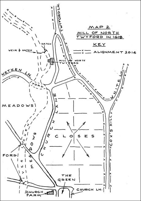
The
closes shown in map 2 and “the Green” are based on a
small archive in the Surrey Record Office K84/39
1-23 1625 to 1786.
Note 4:
Hockley
is both a place name and a family name. Hock - leigh
in OED of Place Names is “spur of a hill - meadow”
and is firstly the name given to the area along the
line of the B3335, north of Twyford. Hockley is also
the name of a Twyford farming family who farmed land
at Hockley in the 1600 and 1700’s. Hockley Mill
seems to be named for the mother of its builder,
Lavington.